Leon McCarron is a writer and broadcaster. He is a Yale World Fellow and the recipient of the Cherry Kearton Medal from the Royal Geographical Society.
Photography by Emily Garthwaite.
AL CHEKA, Iraq — Abu Hasan remembers when they started digging out the dam. With a thick white beard and pristine chequered headscarf that shrouds his eyes, he speaks with youthful expression, though heavy, stiff hands betray his seven long decades. For as long as he could remember, the waters of the expansive marshes of southern Iraq and Iran had been receding, held back by dams and berms, the rivers that fed them diverted upstream. But after the fall of Saddam Hussein’s regime in the spring of 2003, it seemed like they might be coming back.
“When we heard he had gone, there were around 20 of us that started,” he says, sitting cross-legged against the back wall of his guestroom. “There were no shovels, so we had to send someone to borrow them from the Ministry of Water Resources. Then we stood on the dam and dug and dug and released all the water back.” He smiles. “That’s when we saw our marshes returning.”
For two months, I had been following the Tigris by boat, from its mountainous source in southeast Turkey through a pinched corner of Syria and then along the length of Iraq. The goal was to understand the state of the river, especially how global warming and development affect water levels, which those who live in its watershed depend on for their lives and livelihoods. Our team — photographer Emily Garthwaite, environmentalist Salman Khairalla, translator Hana Ibrahim and filmmaker Claudio von Planta — arrived in the Iraqi wetlands in early summer.
The Mesopotamian marshes, named for the historic region defined by the Tigris and Euphrates and often thought to be the biblical Garden of Eden, lie on a vast, flat floodplain where the lower courses of the rivers come together to form an extensive inland delta. Historically, winter rains and snowmelt at the headwaters caused floods to the south, and the marshes would absorb this excess like a sponge, swelling outwards with seasonal growth and then shrinking in the lean summers by draining to the Persian Gulf. The inundations deposited silt from the mountains that fertilized the land, creating a diverse, lush ecosystem in an otherwise arid environment.
Early settlers worked this ground to grow crops and domesticate animals; eventually, around 6,000 years ago, agriculture led to urbanization. These early cities — Eridu, Uruk, Ur and others — relied heavily on the natural resources of the marshes and were strung along waterways and latticed with canals to give access to the plains, the Gulf and to one another. Farmers grew barley and wheat and cultivated orchards of date palms, under which prospered gardens of fruit and vegetables. People dug clay from the ground for pottery, and early forms of writing were developed to keep track of the burgeoning trade between cities. When UNESCO added the Iraqi marshes as a World Heritage Site in 2016, it was in recognition of the area as a cradle of civilization as much as for its biological diversity.


As recently as the 1960s, in Abu Hasan’s youth, the springtime extent of the marshlands was estimated to be as much as 7,700 square miles, harboring a myriad of species of flora and fauna and providing an important stopover for migratory birds on their continental journeys. The wetlands are split between three major areas: the Hammar south of the Euphrates, the Hawizeh east of the Tigris and the Central wedged between. Abu Hasan’s village in the Hawizeh, Al Cheka, is about 13 miles from the border where the waters spill over to the Iranian side and are known as the Azim marshes.
“I was born here, and my father was born here,” Abu Hasan tells me with pride. “In the beginning, we had a reed house, and then a mud one, and then a brick one like this. We’ve always been Marsh Arabs.” He, like many here, claim lineage to the ancient Sumerians.
As his home became more robust, the environment around it was being destroyed. First he recalled British soldiers arriving and drilling for oil, likely in the 1950s. Before the war with Iran erupted in 1980, Saddam Hussein drained the marsh directly behind Al Cheka, and a decade and half later systematically decimated what was left. By 1998, the area was a desert, scorched by fire and encumbered by checkpoints, and the fish and reeds and birds were gone. Over 90% of all the marshes was lost; an area larger than the state of Connecticut shrunk to about the size of the city of Phoenix, Arizona.
When they broke down the dikes, there was some hope, Abu Hasan tells me, and at least it began to look like a marsh again. But looks can be deceiving. “It was never really the same. We used to have so many plants to grow and eat. Now we just have two or three shitty plants. The marshes never properly came back.”
It’s rare that Abu Hasan uses a boat these days. It’s sore on his joints and it makes him sad to see what the marsh has become. Instead, he sends his broad-shouldered nephew, Abu Sajad, to take us out to check on the water buffalo. We follow him down a rough embankment to where waist-high reeds stretch out on either side of a narrow channel until the shimmer of heat smudges the horizon.


Abu Sajad has an assault rifle slung over one shoulder and prayer beads in his other hand. He steps onto the bow of a long, narrow, fiberglass boat modeled on a traditional wood and tar mashouf. Another relative works the motor. Salman and I take the middle, our butts lower than the surface of the water, knees drawn to our chests.
The ride is fitful and the water shallow enough that buffalo walk on the bottom rather than swim. Where they congregate, they have a bad habit of creating earthen mounds that the boat scrapes over, and we stop regularly to lift the engine. There is no shade, no relief from the clawing heat. Mayflies and mosquitos swarm us, getting smeared onto moist foreheads. We pass a herd of pink noses and darting eyes, and I am envious of the buffalo hidden and cool beneath the surface of the water. The animals are Abu Sajad’s, and all are accounted for.
Other waterways become visible, coiling off into the reeds, but most are so small and shallow that even our boat is too unwieldy. Some days, Abu Sajad goes bird hunting through the fissures, but for that he punts in a one-man canoe. We’re boxed in by reeds and sludge. “This is it,” Abu Sajad says. There is open water somewhere beyond, but it is no longer contiguous or accessible from this marsh. We turn back, trapped in a single, claustrophobic channel. It feels like an imitation of a landscape that would deserve the term “wetlands.”
This year, Iraq’s Center for Restoration of Iraqi Marshes and Wetlands estimated the maximum extent of the marshes to be 3,725 square miles, which is less than 50% of the area they covered half a century ago. In the last decade, because of lower water levels, the center has focused on preserving only about half of what remains, and recently they noted that just around 1,000 square miles of wetlands had sufficient water coverage.
There were a few promising years after 2003 when coverage increased, but progress stalled after 2006, declining for a couple of years and eventually plateauing out before the heaviest rains in a generation offered a temporary reprieve in 2019. The population hasn’t recovered either. From a high of half a million in the 1950s, the number of Marsh Arabs living in and around the wetlands fell dramatically, with the majority forced out to the suburbs of Iraqi cities or to flee to Iran. Some never returned. Most of the 250,000 or so who did now live in villages on the fringes of the wetlands or in nearby towns and cities, rather than in them as their parents and grandparents once did.


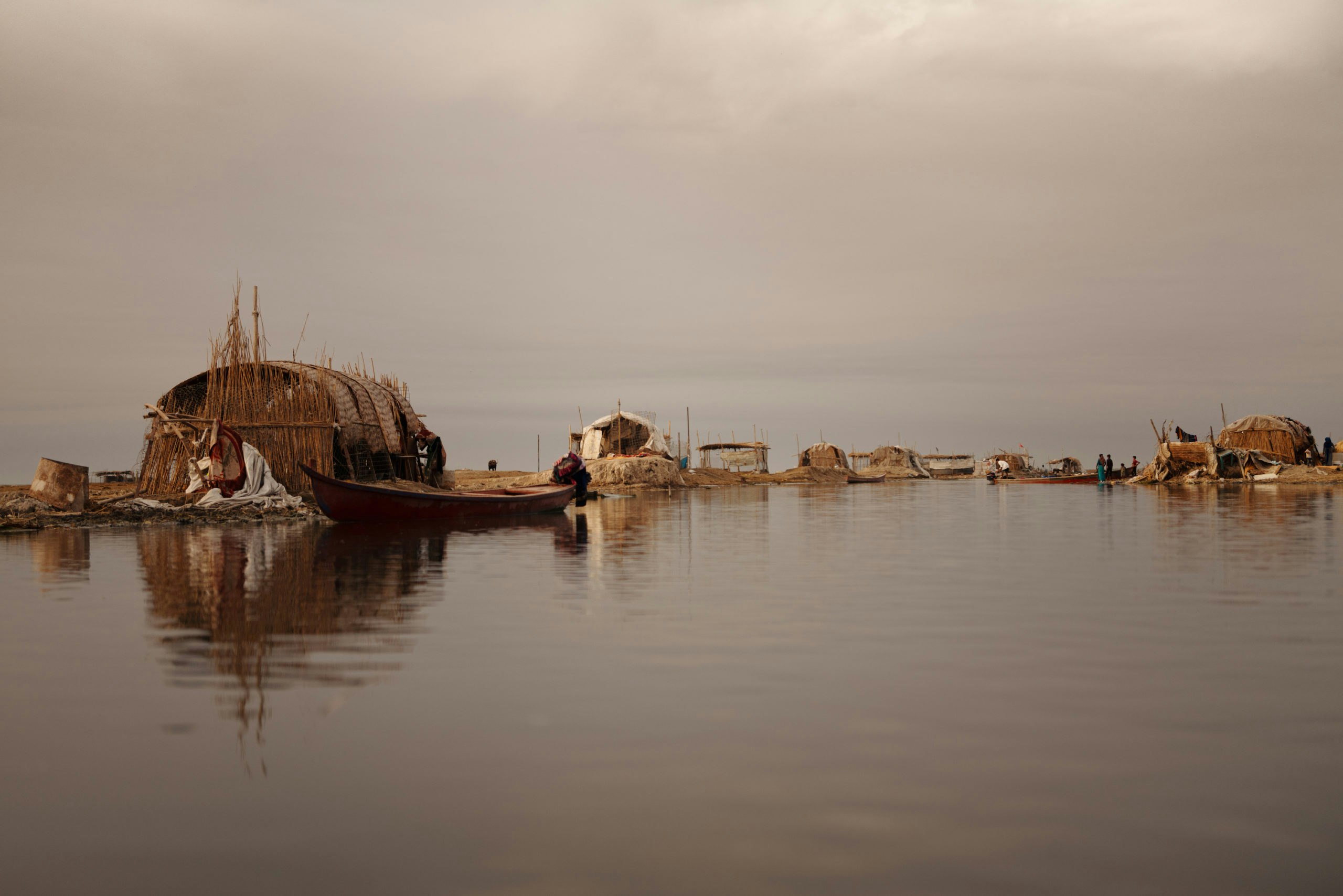
We follow a single-track road around the dried-out area. Flanking the narrow strip of cement are occasional rusting sections of industrial water pumps from the 1990s, now stranded and obsolete, abandoned to the dusty expanse that they helped create. Ten miles on from Al Cheka, we stop to visit a young boatman who has been recommended to Salman as the best person to take us deeper into the Hawizeh. His name is Abbas and at 27, he has only ever known hard times here.
Abbas lives in a small unfinished brick house with his wife Hawra, their three children and seven other relatives. We pitch our tents outside, but the temperature never drops below 85 degrees. It’s a restless night. At 4.30 a.m. the following morning, in semi-darkness, we peel ourselves from the nylon and stumble into the boat Abbas has prepared. He guns the engine along a short canal and out to open water. A perfect amber orb rises over Iran and Abbas carves towards it. Soon we are on a glassy lake lit by nacreous dawn light. It’s oceanic in scale compared to anything we’ve seen so far. When Abbas cuts the motor, for the first time in many months of travel, I can’t hear a thing.
The author Wilfred Thesiger, who lived in the marshes seasonally between 1951 and 1958, wrote of “the stillness of a world that never knew an engine.” Briefly, our imaginations drift there too. Beneath us, algae sway gently like a forest canopy in a breeze.
“This is the purest water anywhere in the marshes,” Abbas says. Carp dart around and kingfishers and gulls fly overhead. There are at least 15 species of fish in the Hawizeh, and over 150 species of birds found throughout the marshes, including four that are endemic and eight that are globally threatened. Some, like the Basra reed warbler, survived the draining of its habitat against the odds, breeding in pockets of remaining reedbed before returning, Phoenix-like, after the re-flooding.
We dock by an island called a chubasha, formed naturally by layers of decomposed vegetation. Heavy reeds grow aggressively, some twice our height. The thicket is only broken by occasional narrow passages that materialize like leads in sea ice, inviting but precarious. The landscape is one of concealment, better at masking than revealing what lies within.
Two elderly fishermen, Abu Fayal and Abu Hussein, are unloading the morning’s catch in a small clearing on the island. They have come from the city of Amara, an hour away, and tirelessly toss fish from boat to box, then clean the nets of scales and algae. Catfish, not considered halal by most Muslims, are thrown back. Binni, short but deep-bodied and endemic to the region, are afforded good care as the most valuable.


Abu Hussein’s boat has no engine and must be rowed or punted. I briefly wonder if one way to make the marshes feel large again is to slow the pace at which you move. Romantic nonsense. It’s 105 degrees in the shade by 8 a.m. “It used to be perfect weather at this time,” Abu Fayal says. “But now it’s hell on earth from May to September.”
Other fishermen in the area use high-voltage transmitters to electrocute fish, killing eggs, bottom feeders and anything else in the vicinity. It’s illegal but widespread and rarely punished. “There’s hardly any fish already, and these bastards kill the rest,” Abu Fayal says bitterly. “In Saddam’s time, he would have hung them.”
Abbas estimates that there are only maybe 100 people still making a living from fishing here, and no permanent inhabitants left inside the Hawizeh. It had been the most resilient area during Saddam’s time because it is fed by the Karkheh River in Iran as well as by the Tigris. But in 2001, Iran started constructing a 40-mile-long embankment to stop water from flowing to Iraq, and now much less comes down the river.
Meanwhile, Turkey, which for decades has pursued the “Grand Anatolia Project” to build 22 dams and 19 power generators on the Tigris and Euphrates, recently completed the vast Ilısu Dam on the Tigris. In the process, the 12,000-year-old Hasankeyf, often identified as one of the oldest continuously inhabited places in the world, was flooded. By December of last year, the dam was working to capacity, with the ability to store over 350 billion cubic feet of water.
Before the reservoir at Ilısu was filled, experts were predicting that the water levels of the Tigris and Euphrates could fall to half their current levels by 2030. Reports on the impact of climate change in the region suggest that rising temperatures at the headwaters of the rivers, along with increased runoff and shifting rainfall patterns, will also cause a decrease in the available water and further exacerbate the decline. Turkey may decide to release ever lower amounts of water into Iraq, adding further uncertainty to the cloudy futures for the last of the Marsh Arabs and the many others whose lives depend on the rivers.


To reach the other marshes, we continue our journey south along the main channel of the Tigris to the town of Qurna, where the Tigris and Euphrates meet for the first time and form the Shatt al Arab. Overlooking the confluence is a small shrine enclosing a decrepit, blackened tree that many local people believe to have been visited by the patriarch Abraham (Ibrahim in Arabic) 4,000 years ago. Others, usually foreign travelers, have also claimed it is the biblical tree of the knowledge of good and evil. If it is sacred, it is also clearly dead.
We detour west onto the Euphrates, heading upstream. Three days after leaving the Hawizeh, we reach a town called Chibayish. This is a gateway to the Central and Hammar Marshes, both of which are primarily fed by the Euphrates. The next morning, early, we switch to a shallower boat and follow a canal leading south to the Hammar. After 30 minutes, once more in a series of natural channels flanked by reeds, we stop at a small chubasha where a woman in a black abaya supervises two teenagers building a shelter. She is called Fatima and lives alone, which is unusual.
Traditionally, women work alongside men in the marshes: rearing buffalo, gathering reeds and traveling to market, as well as producing handicrafts and maintaining the household. As the marshes have suffered, so too have women’s freedoms been curtailed. Men are rarely allowed to speak with women here unless they are related; there are exceptions, like with Fatima, but it was generally more appropriate for our team to conduct interviews with women through our colleagues, Emily and Hana. They were told by women in homes on the margins of the wetlands that outdoor work is less necessary now, so they’ve become confined to their houses, frustrated and unfulfilled. As we found so often throughout Iraq, if a situation is getting worse, women are the first to suffer.
Fatima’s buffalo wallow in a muddy pool nearby. She coos at one named Wardeh — “flower” in Arabic. “Everything in life is good if there’s clean water,” she says. Although she lives on an island, none of the water in sight is of use. “It’s all dirty. I can’t drink it, and even the buffalo can’t. I spend all the money I have on buying fresh water for my animals.”
Fatima leaves to rest in the home of a friend who has an electric fan, and we move on to a larger complex of traditional buildings a few hundred yards away. The closest is arched, bound by exquisite and intricately woven bundles of reeds, and open at one end where the ashes of fire smolder just inside. The smell of freshly baked bread wafts out to greet us. This serifa is the home of Abu and Umm Jassim, and the other two buildings, also of reed, house their buffalo.
Emily and Hana join Umm Jassim inside, and the men sit outside with tea. Aside from a cracked Nokia mobile phone in Abu Jassim’s pocket and a generator covered with blankets in the shade of the serifa, there are few other visible adaptations from the traditional lifestyle. Abu Jassim guesses that unlike in the Hawizeh, there are still a few thousand Marsh Arabs living permanently here in the Hammar. “Our life has always been simple,” he says. “We just need to be able to look after ourselves and our buffalo.” Increasingly, that’s no longer possible.


The water is lower than it has been for years; much of what remains is poisoned, Abu Jassim tells me. The United Nations estimates that 70% of Iraq’s industrial waste is dumped straight into the rivers and ocean, and we’ve seen for ourselves raw sewage discharged all along the Tigris. The salinity of the water is now dangerously high, too. Boat engines corrode, Abu Jassim says, and fish are dying in brackish water. The last time his buffalo drank marsh water directly, one died.
Umm Jassim brings us boiled, sweetened buffalo milk and hot bread, and we recline on the soft reed floor. Her son Jassim plays with a buffalo calf. “You’ve got to earn their trust,” he tells us solemnly, then shakes his tussle of sun-bleached hair and runs inside. I ask Abu Jassim if they’d ever leave. “I couldn’t do that to my wife and daughters,” he tells me. “We can’t go. Not again.”
In the last half-decade, the saline level in some areas has increased by as much as 50-fold. This is in part due to increasing saltwater intrusion from the Gulf, which is in turn caused by the reduced flow of the rivers and rising sea levels. Recently, the U.N. Environment Program named Iraq the fifth-most vulnerable country in the world to the consequences of climate change. In January, President Barham Salih ratified Iraq into the Paris climate agreement and, on World Environment Day, wrote that confronting climate change must be a national priority. He spoke too of returning to Iraq’s ancient greenery, heeding the lessons of the past.
A changing climate is not new to this region, of course. The marshes that fed the early city-states were once much further south than they are today, stretching from the confluence of the rivers all the way to the Persian Gulf. But around four millennia ago, the sea retreated and the land dried out. The marshes receded to their current location, and cities had to innovate again.
For a time, they adapted, arguably with more robust methods of agriculture and irrigation, but in the end they could not survive an increasingly arid climate. Over time, the great cities became ruined, buried in a waterless desert.
Today, the changing climate is manmade. But to truly understand how important the marshes are to Iraq — and to see a glimpse of a possible future, where lakes and waterways dry out to dust — you need only to drive through the hundreds of miles of parched, lifeless land beyond.


Our colleague Salman, whose advocacy work (primarily through an NGO called the Tigris River Protectors Association) seeks to safeguard the waterways of Iraq, notes that the issues in the wetlands are indicative of environmental problems across the whole country. The temperature is increasing, and weather systems are more erratic. Decreased precipitation, drought and desertification are adding to water scarcity. Water-related conflict between families and tribes is becoming more common. Factor in an expanding population and the perpetual cycles of war and instability over the recent past, and it is perhaps no surprise that there has not yet been a government that can address the crisis.
“The Ministry of Water Resources needs to understand the power of the marshes,” Jassim Al-Asadi of the environmental NGO Nature Iraq, who we stopped to talk to on our way back through Chibayish, tells me. Around 80% or more of Iraq’s water goes to agriculture, where a lot is lost via archaic water management and irrigation systems. If the marshes were prioritized, he says, each precious cubic foot would be more productive, and a more productive marsh is important not only for the people who live here, but for us all — vast marshes like these are powerful carbon sinks.
From the outside, change seems unlikely. In 2015, the Ministry of Water Resources recommended several policies to mitigate a vast impending annual water deficit, but none have yet been implemented. Already in the marshes, there is a deficit of at least 180 billion cubic feet of water between what the ministry aims to provide and the amount Jassim and his colleagues estimate is needed.
Our journey ended at the Gulf in early June. I checked back in with Abu Hasan, Abbas, Fatima and Abu Jassim, who variously reported sticky, sleepless nights, stomach complaints, ill or dying livestock and low fish stocks. They fear drought is coming and with it poverty, displacement or both.
I first visited the marshes in the fall of 2018, when low rainfall and other factors in the north meant water levels were lower than they’d been for years. I was told by those I met that they couldn’t survive another year like that one. Miraculous rains saved them then. This time, I asked who they felt could help them now. “Bas Allah,” I was told. “Only God.”
Reporting for this project was supported by the Amersi Foundation. Additional support was provided by the Abraham Path Initiative.