Klaus Thymann is an explorer, photographer, filmmaker, journalist and scientist. A fellow with The Explorers Club of New York and the Royal Geographical Society, he has led more than 60 expeditions across six continents and the world’s five oceans. He is also the founder of Project Pressure, an ecological and climate-focused charity.
TIMIKA, Indonesia — As the helicopter flies above 14,000 feet, the pilot begins inhaling a canister of pure oxygen. “I’m just trying to make sure I don’t pass out,” he assures me. This is reassuring, yet I can’t help wondering: what’s going to happen to me? As a professional explorer, I’m no stranger to altitude or lengthy expeditions, but this is an aggressive and accelerated way to get up a mountain.
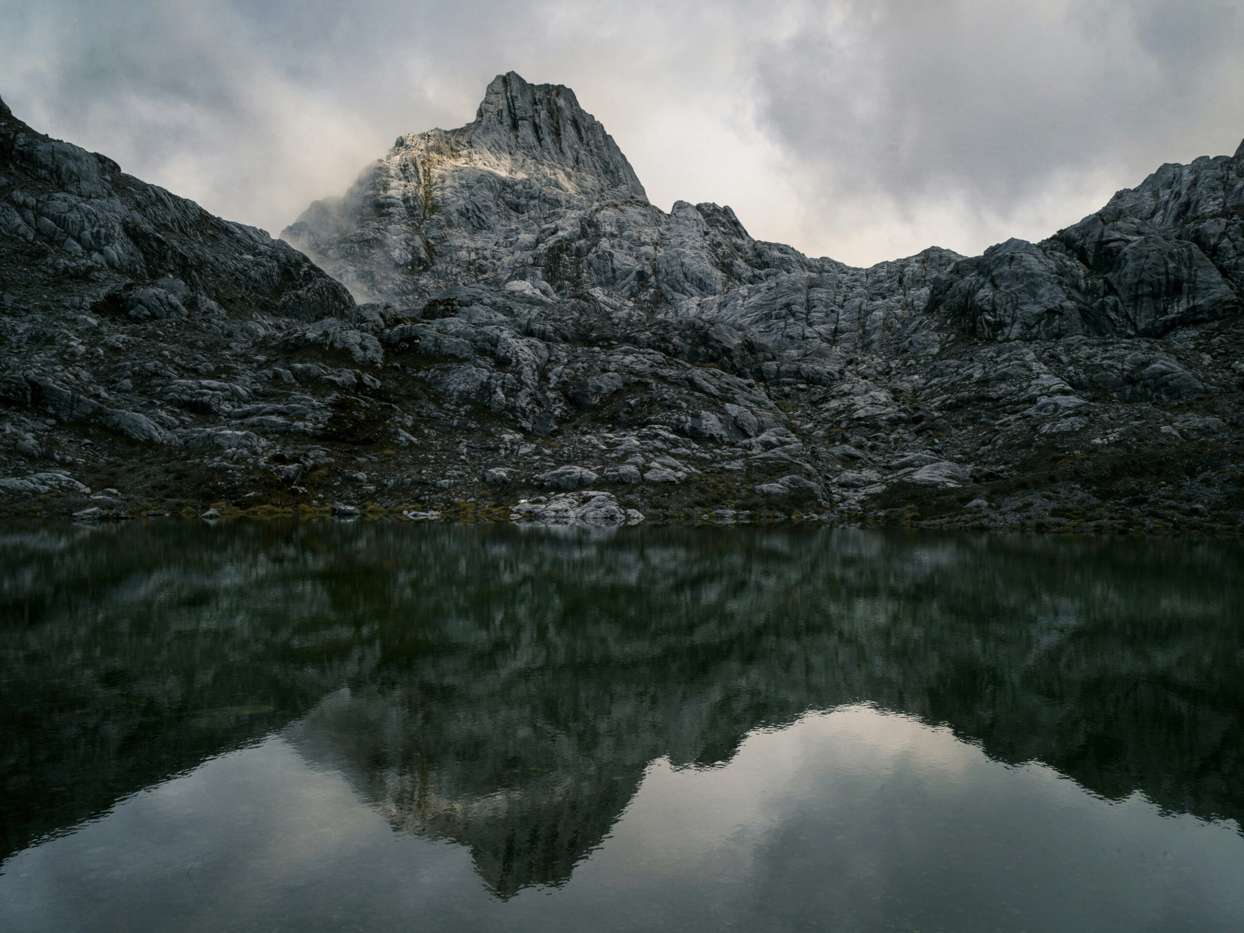
It’s November, and I am here on a mission to map the last remaining tropical ice in Indonesia before it disappears. As one of the famed Seven Summits, the 16,024-foot-high Puncak Jaya is located on the island of New Guinea and is Indonesia’s highest peak. Puncak Jaya is also the highest mountain in Oceania and one of the most topographically isolated in the world. It is surrounded by contested, separatist rebel-held territory that has seen more than six decades of fighting.
Local authorities have intermittently warned against foreign expeditions due to the ongoing fighting. Today, the roughly five- to six-day hike to the summit is banned by the Indonesian government, and the area has a “Level 4: Do Not Travel” warning from the U.S. Department of State, which advises that if you do go, you “appoint one family member to serve as the point of contact if you are taken hostage or detained. Set up a proof-of-life protocol.”
At 7:15 a.m., we are loaded into our helicopter and take off for the roughly 30-minute flight from the sleepy town of Timika, at only 213 feet above sea level. Toward the end of our journey, I can see the Grasberg mine, one of the world’s most productive copper mines, below us. A few minutes after that, we continue up the Yellow Valley as we get closer to base camp. I see about 30 tents, mostly bright yellow, clustered together, my home on the mountain.


The Mission
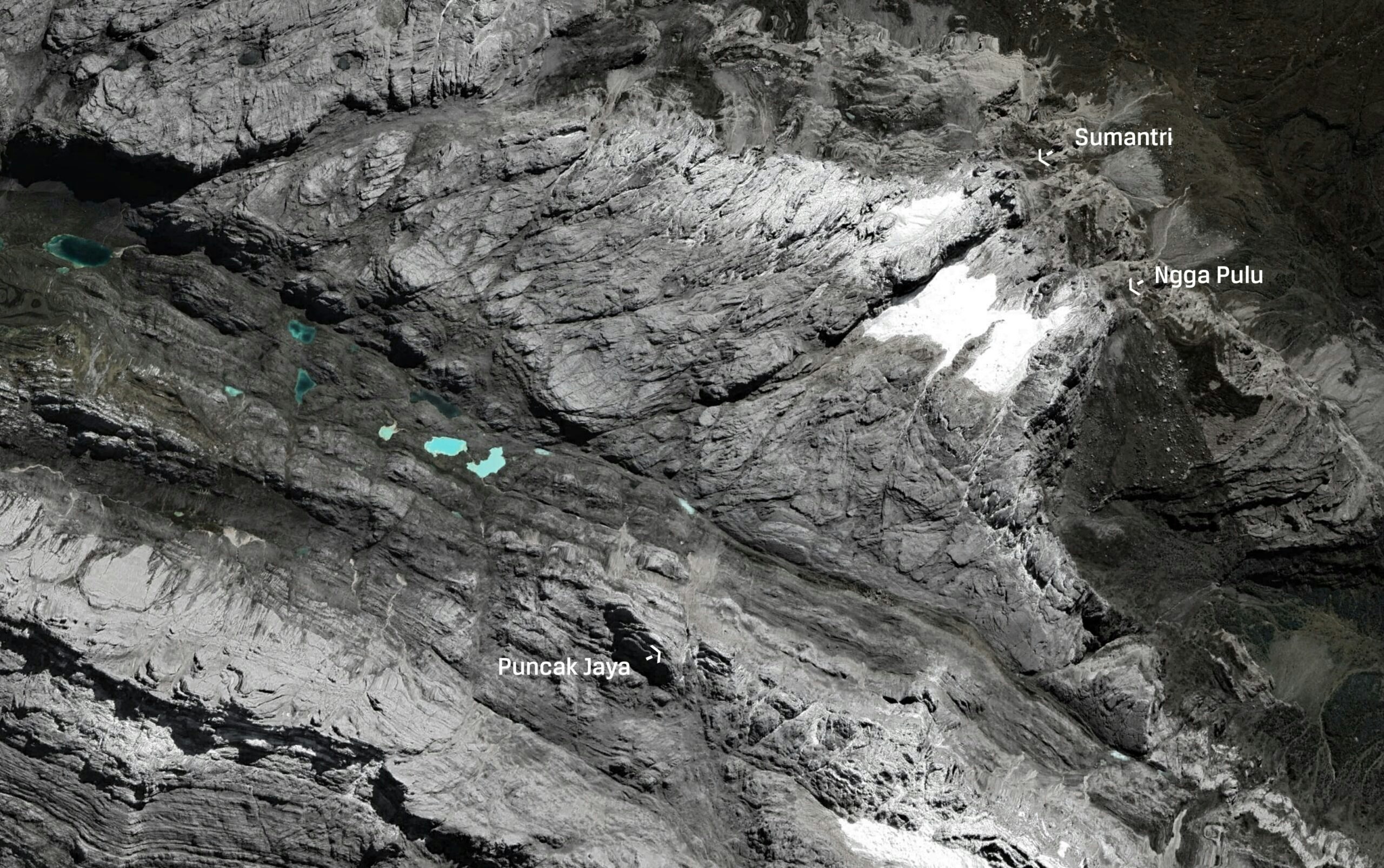
The goal is to produce the world’s first high-resolution, geo-referenced 3D model of the East Northwall Firn glaciers, about 3 miles from the base camp at nearly 15,000 feet. We use drone photography and high-precision geospatial surveying technology to establish coordinates to create a 3D model, allowing the calculation of ice area. Such a scientific and visual legacy of the last tropical glaciers in Oceania will enable other scientists to combine my data on the ice’s surface area with weather data and other historical measurements to better understand how these mountain ecosystems are changing.
But my mission is also about memory — the collective memory of nature. The glaciers, known by locals as Salju Abadi or “Eternal Snow,” and often called the “Eternity Glaciers,” will disappear within the next decade. When they go, a rare part of the tropical cryosphere will be erased, along with a part of the cultural and environmental identity of the Papuan highlands.
Most people don’t realize there are glaciers in the tropics — mention the tropics and we think of palm trees, not ice — and Papua is a very exciting chapter in a line of tropical ice that starts in the Rwenzori Mountains in East Africa and extends to the Andes in Bolivia. Across three continents, I am racing to visually preserve tropical glaciers before they retreat. In each place, I am working to produce 3D photorealistic models before the ice disappears. The models become a kind of visual Noah’s Ark for the future — a high-resolution visual legacy created in minute scientific detail.
Because the impacts of climate change are not uniformly distributed, collecting data on glacier recession in equatorial regions has become paramount. Glaciers are a key indicator of climate change, as their melt shows long-term warming trends. Glaciers in the tropics exist far from polar influences, and only because high altitudes create conditions where temperatures dip below freezing. They are therefore the most sensitive to changes in temperature and are like canaries in the climate system. When they shrink year after year, it is a clear signal of long-term warming. Their disappearance will erase a rare part of the tropical cryosphere and a measurable baseline for understanding what is happening in places that are otherwise hard to monitor.
Over the past two decades, I’ve led more than 60 expeditions to extreme environments, developing field methods that combine drone photogrammetry, geospatial analysis, and image-making to document fragile ecosystems under pressure. This is the final call for Papua; the ice will be gone soon.
“Most people don’t realize there are glaciers in the tropics — mention the tropics and we think of palm trees, not ice.”
The History
Puncak Jaya sits in Central Papua on Indigenous land, and the mountain carries Indigenous names and meanings that predate modern maps. Its Western name dates to 1623, when Dutch explorer Jan Carstenszoon reported seeing snow and glaciers near the equator, a claim that earned him ridicule across Europe and went unverified for centuries. In 1936, a Dutch expedition finally verified the explorer’s claims, and the name Carstensz Pyramid became the European name for the peak.


Then came extraction. The expedition’s geological report was initially overlooked and only rediscovered by the mining company Freeport in 1960, triggering a mining push that grew through the 1970s into what is now the Grasberg mining district, which holds one of the world’s largest gold and copper reserves on the mountain of Puncak Jaya itself.
It’s hard not to feel the symbolism. The same economic logic of extraction, which results in the industrial-scale mining of metals from these mountains, is also driving the emissions and energy demands that are unraveling the climate.
The Glacier
In this part of Indonesia, there are generally two seasons: dry and wet. Even in the supposedly dry season, there are plenty of clouds and rain; it rains about 300 days a year here.
Navigating in the mountains at altitude is tricky because microclimates, unpredictable mountain weather and limited visibility mean pilots must navigate visually and for the helicopter to take off, the skies must be cloud-free across the entire journey: no clouds at the airport in Timika, clear in the mountain valleys and also good visibility at base camp. It’s effectively a cloud lottery — all three locations must be clear for the helicopter to take off.
After landing at base camp, I am eager to visit the glacier. While on standby for government approval to traverse an adjacent valley frequently used by rebels, I chat with some of the commercial clients planning to summit. Most aren’t aware of the basic rope techniques necessary to safely summit. Because it is one of the Seven Summits, Puncak Jaya has experienced some of the impacts of the growing commercialization of mountaineering and a tourism industry that caters to peak baggers with money. Conquering the mountain is their goal; the dwindling ice is not the main attraction. In contrast, my data-driven endeavor is my primary objective, not the summit.

After many conversations over the radio, the trekking company finally gets approval to travel to the ice-covered area of East Northwall Firn the next day.
At 5:30 a.m. the next morning, my team of five people — me, a field assistant, our guide and a military escort of two soldiers armed with a radio and Kalashnikov assault rifles — set off from base camp. Our guide can hardly walk and complains of a headache. These symptoms of altitude sickness mean it’s no longer safe for him to advance higher up the mountain, and he must return and rest. There is a risk of cerebral edema, or worse. I grab the guide’s nearly 45-pound pack filled with survey equipment, including a lot of additional batteries for the drone, and haul it onto my shoulders along with my own, as our guide turns back with a soldier accompanying him.
From the Yellow Valley, we hike up a ridge, and after about a mile, we pass through the Danau-Danau Valley, which is dotted with beautiful blue lagoons. It’s already about 7:30 a.m., and from here, it’s about a two-hour hike up to the ice. Above us, the clouds are already lowering fast when we reach the glacier. We move quickly, placing four bright 50 x 50 cm ground control points. Then I launch the drone and begin photographing the mountain and ice from above, including these control points, to ensure that real-life measurements are accurately transferred as coordinates to the 3D model.

The drone captures hundreds of overlapping images, every photograph slightly intersecting the next. Later, software will stitch these together, matching the visual overlaps so that they form a complete jigsaw puzzle. If I miss a section, the puzzle has a hole. If I don’t capture the ground control points clearly, the puzzle has no measurable size. As I race to capture photos, the clouds begin swallowing the upper ice. First, the summit disappears, then the ridgeline. I am in a race against nature, and soon it’s impossible to continue surveying, so we return to base camp.
“This is the final call for Papua; the ice will be gone soon.”
Back at camp, the summit clients are happy: They successfully reached the top while the weather was still dry and returned in the rain. Now they are eager to be helicoptered back to town.
But it rains for days. The days blur into a homogenous mush. Each morning, I wake up at 4:30 a.m., ready to finish the drone survey of the upper parts of the ice. But the pouring rain means no one, let alone the drone, can see the upper parts of the mountain and the ice.
While we wait, I go on rainy treks with one of the lead soldiers. One of the things I love about the mountains is that it makes you humble. I love that there are things you can’t control, and it makes you realize that nature has all the power. Not everyone is willing to acknowledge this. I was told that one of the premium climbing companies on site had a Saudi prince who was also stuck like us for almost a week. In the end, the Saudi ambassador called the company and instructed them to use cloud seeding to get rid of the rain clouds and arrange for a military helicopter to pick him up. (He didn’t leave the mountain until the clouds cleared naturally after about 10 days).
After five days of rain and grey skies, I peek out of my tent at 1:45 a.m. and finally see a few stars — a good sign. I attempt to sleep for a couple more hours, and then at 5 a.m., I set off at a brisk pace with a big backpack full of gear for the ridge overlooking the glacier. As the dark turns to dawn, I catch a gloriously clear view of Soekarno Peak, with a dusting of snow above the freezing-point elevation. You never know how long it will stay cloud-free, so working fast is key. I pull the drone out quickly to continue the survey until the full jigsaw puzzle is captured and stored as digital memory.
Alpenglow
Walking back several hours later, I’m exhausted. Tears fill my eyes as I reflect on the weeks-long journey to create this scientific record of this disappearing tropical glacier. I think of my daughter, who will grow up in a world where this ice and so many other glaciers are gone.
Centuries ago, it was so hard to believe there was ice at the equator that, in Europe, the explorer who returned with the claim was mocked. Now we have reversed the situation: for many, it is unfathomable that such glaciers will one day be extinct and that some even question whether climate change is real. The cliché “seeing is believing” rings true, though. In the natural world, standing in front of a massive mountain provides a humbling perspective and, in Papua, also the understanding that we have irrevocably altered the natural way of life: we have melted mountains. The question is whether this “eternal snow” can live on in some other way after the glacier is gone. Only time will tell.

Credits: Additional research by Allison Brown. Photography by Klaus Thymann. 3D model team: Lead scientist Klaus Thymann; Geospatial support, Arnaud Lezennec/Trimble; Assembly by Anastasis Spachos & Martin Rehak/Pix4D; Animations by Project Pressure


